


Preview
Publication Date
1878
Publisher Location
London
Publisher
Robinson, Macy & Fairbairn, City Engineers Office
Scale
10 chains to 1 inch
Geographic Area
London (Ont.)
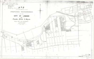
Description
Area of Thames River between Byron at left of page and Wharncliffe Road ("Wharncliff Highway") at right, and Commissioners Road at bottom.
Text in upper left corner: "This is one of the Drawings referred to in Our contract dated April 4, 1878." signed Thos. A. Stevens, W. Turner, James Burns, John Carling, Chairman.
Physical size
91 x 58 cm
2980601.jpg (261 kB)