

Shaping the Metropolis: Institutions and Urbanization in the United States and Canada by Zack Taylor
Files
Download Item (1.7 MB)
Description
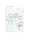
Note: Only selected lower-tier municipalities are represented and labelled. The planning area of the Metropolitan Toronto Planning Board encompassed an area approximately double that of Metro Toronto itself, in Peel, York, and Ontario Counties. With the exception of the western half of Toronto Township in York County, the jurisdiction of the Metropolitan Toronto and Region Conservation Authority (MTRCA, established in 1957) included all of this area and also the headwaters of the Humber, Don, and Rouge Rivers to the north.
Publication Date
5-9-2019
Sources
Sources: Municipal boundaries from Canadian Century Research Infrastructure Project; MTRCA boundary from Conservation Authority Administration Delineation 2004, Ministry of Natural Resources.
Recommended Citation
Taylor, Zack, "Figure 4.5 The Toronto region, 1954.pdf" (2019). Shaping the Metropolis: Institutions and Urbanization in the United States and Canada by Zack Taylor. 9.
https://ir.lib.uwo.ca/shapingthemetropolis/9