


Preview
Publication Date
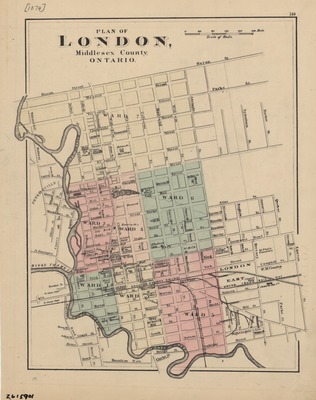
1875
Publisher Location
Place of publication not identified.
Publisher
Publisher not identified.
Scale
1 cm = 40 rods.
Geographic Area
London (Ont.)
Description
Map of London, Ontario, circa 1875, highlighting political wards in colour, street, railways, and locations of some buildings.
Physical size
48 x 28 cm
2103301.jpg (429 kB)
Notes
p. 159 of Tackabury's Atlas of the Dominion of Canada / Henry Francis Walling. Montreal, Tackabury, 1875.
Written in lower left-hand corner: "2615901".