


Preview
Publication Date
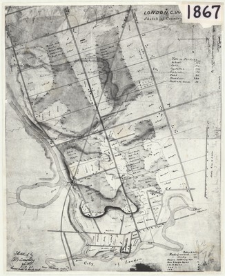
1867
Scale
6 ins = 1 mile
Geographic Area
London (Ont.)
Map Theme
Agriculture; Land use, rural; Roads
Description
Sketched map of crops grown in London, Ontario in 1867, with type of crop written in each section of the map. Also lists type of road (gravelled or sandy) and houses by number of rooms. Types of croplands listed include: wheat, oats, vegetables, orchards, peas, meadow, and Indian corn.
Physical size
40 x 32 cm
2101801.jpg (444 kB)
JPG version
JPG version
Notes
Creator name difficult to read: "Sketched by [R.M. Armstrong?]."
Dated "8.7.67"
"Local map of roads used."