


Preview
Publication Date
11-1839
Publisher Location
Place of publication not identified.
Publisher
William Eyre
Scale
Six inches to a mile.
Geographic Area
London (Ont.)
Map Type
Watercolour/drawing
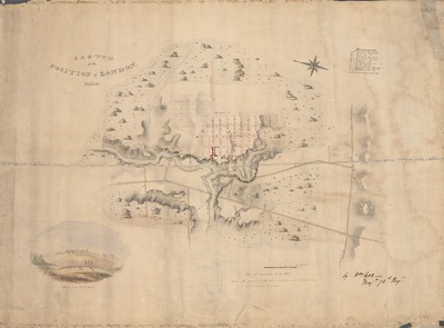
Description
Sketch of the position of London: U.C. Nov'r 1839, including inset "Sketch of the Court House".
Physical size
54 x 75 cm
CX1006.jpg (268 kB)
Notes
Includes references to barracks, churches, courthouse, and bridges.
"Mem'm: The course of the River marked with dotted lines is not correctly laid down."
"By Wm. Eyre, Maj'r 73d Reg't"
Oriented with north to the left, angled slightly upward