


Preview
Publication Date
8-1879
Publisher Location
London, Ont.?
Publisher
R.P. Fairbairn, P.L.S.
Scale
Scale - 200 feet to 1 inch
Geographic Area
London (Ont.)
Map Theme
Land subdivision, Kensal Park
Map Type
Drawing
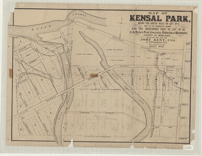
Description
Map of Kensal Park, London, Ontario, showing subdivisions of the south half of Lot No. 5 and north part of Lot No. 33, prepared for John Kent by R.P. Fairbairn.
Handwritten notation outline lot locations, where lots are to be split, mathematical calculations, and additional information.
Physical size
49 x 64 cm
CX828.jpg (427 kB)
Notes
"August, 1879"
Map oriented with north slightly to upper right.
Some relief shown by hachures.