


Preview
Publication Date
1871
Publisher Location
London, Ont.
Publisher
Publisher not identified.
Scale
Scale not given
Geographic Area
London (Ont.)
Map Type
Drawing, facsimile
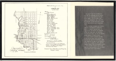
Description
Plan of the city of London Ontario, A.D. 1871. Designed by H.A. Wilkens. Original map published 1871. Facsimile of map imprinted on parchment; Facsimile publication unknown.
See "notes" for story.
Physical size
63 x 33 cm
2102501.jpg (226 kB)
Notes
Lists "Members of the Corporation of the City of London, Ont, A.D. MDCCCLXXI" (1871)
"Assessed Value of Real & Personal Property, 5,457,383 Dolars."
Text included with the map tells the history of the map's discovery:
"This map of the City of London Ont. A.D. 1871, was recovered from the Corner-Stone of a building erected by the late Charles Dunnit, on a site then in the Township of Westminster - now in the City of London Ont. - on the North side of Becher Street, near the West end of King Street Bridge.
"This building, although never actually completed, was apparently planned as a Hotel to be called 'Charing Cross'. In time however, the Property was purchased by the late James Seale, who demolished the unfinished hotel, and used it's masonry in the erection of near-by houses.
"A metal 'Carton' protected the Plan of the City of London above referred to. The Plan was imprinted on Parchment, which also comprised the names of the Corporation of the City of London A.D. 1871, with the Assessed value of Real and Personal Property.
"The recovered 'Carton', and it's Map are now in the possession of Mr J.A. Childs of 21 Becher Street London Ontario."