


Preview
Publication Date
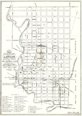
3-1856
Publisher Location
London, Ont.
Publisher
George Railton
Scale
16 Chains to an Inch
Geographic Area
London (Ont.)
Map Type
Drawing
Description
Map of the city of London, surveyed and drawn by Sam'l Peters, P.L.S., published by Geo. Railton, for the London Directory, 1856.
Physical size
43 x 28 cm
2102201.jpg (380 kB)
Notes
Points of interest marked (e.g. courthouse, churches, banks, hotels, industries, wards, etc.).
"Samuel Peters Lith., London C.W., March 1856."
Map oriented with north to upper right.
Published for the London Directory.