


Preview
Publication Date
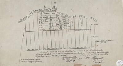
12-22-1830
Publisher Location
Port Talbot, Ont.
Publisher
Surveyor's Office, M. Burwell
Scale
40 chains to one inch
Geographic Area
London (Ont.)
Map Theme
School sites
Map Type
Drawing
Description
"School Reserve in the Broken Front of Westminster, Shewing [showing] the lots, and their respective contents, on each side of Wharncliffe Highway, and Wortley Road."
Physical size
45 x 65 cm
2357601.jpg (226 kB)
Notes
"By Surveyor's Office, Port Talbot, 22nd Dec. 1830, PE.7. M. Burwell"
"To William Chewett Esquire, Acting Surveyor General"
Oriented with north to the upper right