

Shaping the Metropolis: Institutions and Urbanization in the United States and Canada by Zack Taylor
Files
Download
Download Item (10.8 MB)
Publication Date
5-7-2019
Sources
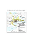
Sources: Municipal boundaries adapted from Statistics Canada cartographic boundary files. Urbanized area for 1941 adapted from Harris and Luymes, “The Growth of Toronto”; 1971 from Canada Land Use Monitoring Program, Natural Resources Canada; and 2006 from Ontario, Built Boundary; Greenbelt, Oak Ridges Moraine, and Greenbelt boundaries from Government of Ontario.
Recommended Citation
Taylor, Zack, "Figure 4.2 Administrative boundaries, urbanization, and policy areas in Toronto.pdf" (2019). Shaping the Metropolis: Institutions and Urbanization in the United States and Canada by Zack Taylor. 7.
https://ir.lib.uwo.ca/shapingthemetropolis/7