

Location
Lambton-Middlesex, Ontario, Canada
Start Date
23-6-1944 4:00 PM
Document Type
Report (PDF/Word)
F-Scale Rating
F3
Classification
Probable
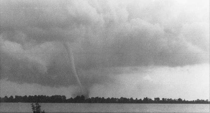
Description
A very strong tornado touched down just west of Birnam, Lambton County and began to track SE toward Wisbeach, passing on the west side of the hamlet. It then tracked another 2km SE before turning east along what is now Highway 402 at the Lambton/Middlesex County line, where it inflicted severe damage to a sugar bush, travelling east for an additional 5.5km. Yet again, it then took a SE turn down to the current day Mullifarry Drive, widening out and tracking parallel to the road for about 6km while damaging nearly every farmstead along its path. About 1km west of Highway 81, it turned and widened to the SE again now passing just to the north of Strathroy town centre. As it passed this area the tornado is believed to have widened to approximately 1 mile or 1.6km before nearing County Road 39. After passing County Road 39, it narrowed and possibly weakened or lifted slightly for 2km, but near the intersection of McEvoy Road and Walkers Drive, began to pick up again, widening it path of destruction to back to about 1.6km. Turning slightly SE again, it went another 4km to Olde Drive where it may have weakened or lifted slightly, and turning to the east, following the CN rail corridor into Lobo Township toward Komoka. Continuing east on the south end of Komoka, it began to turn toward a more southerly course heading toward the Thames River, southeast of town. It then crossed the River and headed over County Road 3 (Gideon Drive) now at a SSE trajectory. At this point, it once again either lifted slightly or weakened and continued SE for 8km over the countryside, tracking parallel to Longwoods Road. At the intersection of Murray Road and Longwoods Road, it turned to the east, still following Longwoods Road directly into the town of Lambeth. The tornado then weakened and lifted just north of the town.
Another 7.53km path of damage parallel to the parent track was indicated on the track map beginning just west of Sharon and ending on the east side of Scottsville, approximately 3km SSE of Lambeth.
Birnam to Lambeth
Lambton-Middlesex, Ontario, Canada
A very strong tornado touched down just west of Birnam, Lambton County and began to track SE toward Wisbeach, passing on the west side of the hamlet. It then tracked another 2km SE before turning east along what is now Highway 402 at the Lambton/Middlesex County line, where it inflicted severe damage to a sugar bush, travelling east for an additional 5.5km. Yet again, it then took a SE turn down to the current day Mullifarry Drive, widening out and tracking parallel to the road for about 6km while damaging nearly every farmstead along its path. About 1km west of Highway 81, it turned and widened to the SE again now passing just to the north of Strathroy town centre. As it passed this area the tornado is believed to have widened to approximately 1 mile or 1.6km before nearing County Road 39. After passing County Road 39, it narrowed and possibly weakened or lifted slightly for 2km, but near the intersection of McEvoy Road and Walkers Drive, began to pick up again, widening it path of destruction to back to about 1.6km. Turning slightly SE again, it went another 4km to Olde Drive where it may have weakened or lifted slightly, and turning to the east, following the CN rail corridor into Lobo Township toward Komoka. Continuing east on the south end of Komoka, it began to turn toward a more southerly course heading toward the Thames River, southeast of town. It then crossed the River and headed over County Road 3 (Gideon Drive) now at a SSE trajectory. At this point, it once again either lifted slightly or weakened and continued SE for 8km over the countryside, tracking parallel to Longwoods Road. At the intersection of Murray Road and Longwoods Road, it turned to the east, still following Longwoods Road directly into the town of Lambeth. The tornado then weakened and lifted just north of the town.
Another 7.53km path of damage parallel to the parent track was indicated on the track map beginning just west of Sharon and ending on the east side of Scottsville, approximately 3km SSE of Lambeth.