


Preview
Publication Date
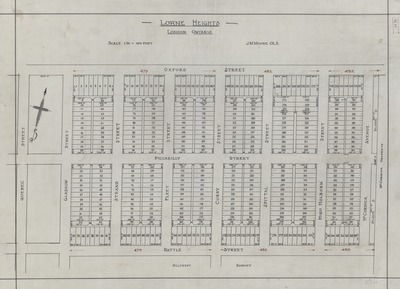
1900
Publisher Location
London Ontario
Publisher
Publisher not identified
Scale
1 in. = 100 feet
Geographic Area
London (Ont.)
Map Theme
City planning
Description
Hand drawn map of proposed Lorne Heights subdivision by architect J. M. Moore OLS
At bottom of map: Hillcrest Survey
Physical size
43 x 61 cm
C526.jpg (330 kB)
Notes
Publication date unknown; approximately 1900 or earlier.