


Preview
Publication Date
1830
Publisher Location
Place of publication not identified.
Publisher
Lewis Grant
Scale
Twenty chains to one inch
Geographic Area
London (Ont.)
Map Type
Drawing
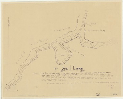
Description
Map produced by surveyor Lewis Grant in 1830 based on field notes of Augustus Jones from 1792-1793.
Physical size
53 x 35 cm
2357501.jpg (181 kB)
Notes
Includes remarks from field notes including a description of the Thames river, measurements of height of the the river in different seasons, and measurements of the height of the river banks.
"Compiled field notes of Mr. A. Jones by Lewis Grant DPS."
"Copy W.C." (or W.G.?)
Publication date unknown.