


Preview
Publication Date
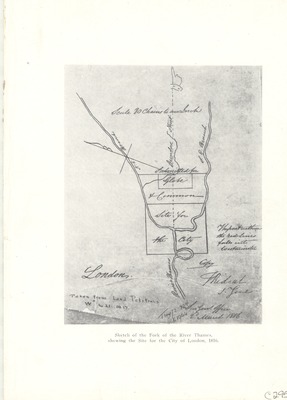
Spring 3-2-1816
Publisher Location
[London?, Ontario]
Scale
80 chains to an inch
Geographic Area
London (Ont.)
Map Type
Line (sketch) drawing
Description
Line drawing (sketch) using a stylus on paper of a map of London, Ontario. Dundas Street is the only street identified in relation to NE and SE branches of the Thames River.
Physical size
16 x 12 cm
C295.jpg (245 kB)
Notes
"The part within the red lines falls into Westminster."-text on map.
"Taken from land petitions W" no. 21 1817."-text on map.
"Survey office 2nd March 1816."-text on map.
"Submitted for Glebe & Common."-text on map.
Map oriented from an easterly (top) to west (bottom) direction. Due north indicated on map.